An extremely rare “plain” wheellock pistol circa 1585.
From the workshop of Peter Danner.
(Ex. Evan Perry collection. Ex. Royal Armouries.)
(photos courtesy of F.J.A.G.)
Odd View eh?
And why you ask is it so very rare?…
Well… it’s because our old friends the “Victorians” took most of the surviving examples, and “improved” them with lots of lovely etching and gilding… and the ones that managed to escape their attentions, are now the rarest of all!
(Watch out, ’cause they did it with armour as well.)
These plain straightforward guns must have been produced in their thousands… but few have made it through to the present day.
They are also the direct ancestors of the Scottish all steel pistols made at Doune (and elsewhere.)
See what I mean… that’s the wheellock under discussion at the back… and that in front of it is an Alexander Campbell (Doune) of the mid 18th century.
Alex. Campbell is reckoned to be about as good as it ever got. And so that above represents the beginning and the end of the “Scottish” (sic.) pistol, or more correctly of the all steel pistol in Scotland.
Here are some more views of both pistols:-
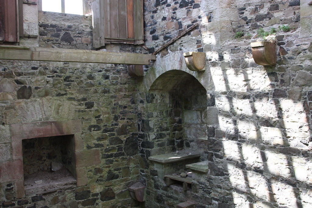
There ought to be a belt hook on this side, but unfortunately it has not survived.
Yes!… As the eagle eyed amongst you will have noted, Mr Danner’s initials, are out of line, and struck the wrong way around?
And that is why I’ve classed it as “workshop of” rather than “by.”
Imagine the situation… the pistol has been completed… It is perfect… it is inspected… it is given the Nuremberg Guild mark…. and then?….
Oh dear… the circumstances will be familiar to anyone who has worked in a large machine shop…
The gun is passed over to the “apprentice” to strike the final marks…. A simple enough task… and surely not outside of his capabilities?
But… the apprentice has celebrated the weekend rather too enthusiastically, and is suffering the aftereffects of imbibing copious amounts of fine German Beer….
He picks up the punches… he wavers… and then… he strikes…
Those rather out of kilter initials… D…. P.
Acht! Gott im Himmel…. They are the wrong way around!
Quickly, surreptitiously, he the conceals his mistake by placing the gun at the bottom of the batch of pistols he is working on….
Perhaps if he is lucky… His master will never notice.
Today…. We can view it as a little human touch… and one which adds interest to the piece.
Lord knows what Mr Danner would have said!
In the North East… where I come from… such things were referred to as “Monday morning pieces.”
Nothing really changes does it.
So remember… Never put your precious motor vehicle in for service on a Monday.
Detail of the initials.
The label on the butt plate is original to the Evan Perry Collection.
Like the little “boxing hare” locksmiths mark?
All in all, a fine untouched and interesting pistol of around 1585, with just that little extra added eccentricity.
This is what it eventually evolved into…
The Scots turned the ends of the butt plate down into “ramshorns” and came up with their very own style!
Note the belt hook, which is missing from the Nuremberg pistol.
That is a worn example which has probably seen a lot of action… but as I said above… Alexander Campbell of Doune is about as good as it gets…
Here are the dimensions:-
Wheellock :-
Weight :- 2 pounds 9 and a half ounces.
Overall Length :- 15 and three eighth inches.
Bore :- half an inch. .50 … about a half ounce ball?
Barrel :- 8 and one quarter inches from touch hole to muzzle.
Alexander Campbell :-
Weight :- 1 pound 4 and three quarter ounces.
Overall length :- 12 and seven eighth inches.
Bore :- nine sixteenths of an inch. .56 inches. Bit over a half ounce ball…
Barrel :- 7 and five eighth inches touch hole to muzzle.
But… a “munitions,” (?) burgonet with a one piece skull, hammer raised by a Master Armourer.
Although from an armoury containing mostly “munitions quality” helmets, this one stands out.
It bears neither an armourers mark or a guild mark. But with work of this quality, why shouldhe bother to sign it, since back in those days the quality alone, would signal exactly who made it.
This is freehand sculpture in metal, of the very highest standard.
Dimensions:-
Front to back:- 11 and one quarter inches.
Width:- 8 inches.
Height:- 11 and one quarter inches.
Weight:- 3 lbs 12 ounces.
Right View.
Left View.
Front View.
Showing original lining.
Back View.
Top View.
Note the fine quality of the “roping.”
View from below back.
The line of that comb is just perfect!
And the broken leather strip is the original suspension for hanging the helmet on a peg!
Never seen that before.
There… you can see it better from the front below.
But just look at the line of this helmet in the photos below…. Incredible… and remember, this is a man working fast and freehand, on munitions work.
Not spending weeks, or even months, on the armour of some little Lord Fauntleroy, who wants a nice shiny suit to prance around in on parade day…. this really is a fighting man’s helmet. And anyone who has ever picked up a hammer and tried their hand at raising metal will appreciate just how difficult it is to achieve such an elegant balance of curves.
Armour, and fighting armour in particular, is quite probably the most difficult, and least appreciated form of Art metalwork. It also has to be superbly functional…. which parade armour although magnificent in its own right, for certain…. is not.
This burgonet is all about the curves of light playing upon metal, and the production of an elegant shape with few surfaces for a weapon to grip upon… in fact… almost early “stealth technology?”
See how the comb curves into the bowl? No ridge for a blade to gain purchase in… clever… don’t see that too often.
I’d love to know just who did make this one….
As you can see from the photo below…
The left cheek piece has been reworked after some battle damage.
Just beautiful… and in my own humble opinion, about as good as it ever gets.
Those of you who regularly follow this blog, will no doubt have noted the similarity to the “Howard Curtis” Burgonet of The “Steel Bonnet” post 5. (10/3/13.)… Same hand…. possibly?…. Same School… Maybe?
Why not go have another look, and make your own minds up!
The three great heroes of the Wars of Independence.
(Keeping it brief!)
William Wallace, Robert Bruce, and Sir James “The Good” or if you prefer it Sir James “The Black” Douglas.
As we all know, Wallace died at the hands of the English in 1305.
Bruce united Scotland, became it’s King, and died of leprosy on June 7th 1329.
His last wish, spoken directly to his friend and lieutenant, Sir James Douglas, was that after death, his heart be removed, and taken by Douglas to the Holy Sepulchre at Jerusalem.
The elaborate preparations for the journey took around nine months, but in the spring of 1330, Douglas set out in the company of a group of knights including a certain St Clair of Rosslyn.
It has been commented that the progress was carried out with full pomp and ceremony. A Royal Progress, just as if King Robert himself was actually present.
Unfortunately, in August of 1330, whilst travelling through Spain, the group decided to join forces with King Alfonso in his campaign against the Moorish emirate of Granada, and Sir James, still carrying the heart of Bruce in a casket around his neck, was cut off from the main body of troops, surrounded, and killed.
His last action before his death was to remove the casket, and throw it forward over the heads of his enemies, with the immortal words “Forward Brave Heart.”
Douglas was found after Alfonso’s victory, dead upon the field of battle, with the heart lying beneath his body. Although some authorities claim that it was not the physical heart, but a device emblazoned upon his shield.
(If this was so…. then why would the heart not also be inlaid upon the blade of his sword… after all he did have nine months to prepare….)
Whatever… Bruce’s heart was recovered…
Douglas’s heart was removed…. his body was rendered down… the flesh was buried in Teba, and his bones together with his own heart, and the heart of Bruce were returned to Scotland.
Heart casket of Sir James Douglas,.
St Brides Church, Douglas.
Douglas’s heart and bones were buried at St Brides Church, Douglas, South Lanarkshire where they remain, whilst Bruce’s heart lies buried at Melrose.
The story is well known.
Now for those who may think I went a little far with the last posting…..
The death of Sir James Douglas whilst carrying the heart of Bruce to the Holy Land, was to Scotland, to put it in modern terms, the equivalent of the death of Princess Diana, and “911” rolled into one.
The Nation was devastated.
The last great hero of the Wars of Independence, killed, whilst carrying the heart of the King to the Holy Land….
And it is my contention, that it was at this moment in history… that Scotland took up the image of the heart, as the iconic image of both fidelity, and of the Nation’s Independence.
Heart brooches, later to be known as “Luckenbooths” or “witches brooches” first make their appearance in Scotland at almost the exact time of the death of Douglas.
They appear to have been exchanged by lovers as symbols of fidelity, performing much the same function as the modern engagement ring, but they also had a second function, of warding off the “evil eye,” (hence “witches brooches,” not because witches actually wore them, but to keep them away.)
Many were passed down, generation to generation, and often bear more than one set of initials on the reverse.
Heart Brooch circa 1400 found in Fife.
And all of this, goes very much further…..
In 1274, John Balliol of Barnard Castle, died. (no, not the “Puppet King of Scotland”… his Dad!)
John’s wife Devorgilla, “The Lady of Galloway,” had his heart removed… embalmed… and carried it about with her, in an ivory and silver casket for the remainder of her life.
Upon her death, it was buried with her at Sweetheart Abbey, in Dumfries and Galloway… and yes… that is where the name came from.
Sweetheart Abbey, New Abbey, Dumfries.
(Don’t get many days like this one… fine, light angles just right, and no visitors wandering all over in front of the camera!)
(That little figure, centre frame, is my Maureen, taking a photo of me, taking a photo of her, taking a photo of me…. daft aren’t we?)
And here it is looking the other way.
This is Sunday morning in the Borders in high summer on one of the major “Tourist Trails”, but there are no folk in the frame….. Probably because you have to pay to get in…. and that can get expensive…
So a lot of visitors, particularly those with a couple of kids, simply take a couple of “snaps” over the fence, then make do with sitting in the sunshine in the little cafe opposite with a coffee and a sandwich.
But “empty” places have far more atmosphere… And so, for us, it was worth it, just to be able to stand alone, and undisturbed in that side chamber with Devorgilla’s tomb, (see below,) and to be able to take these photo’s….
(Note:- If you insist upon doing the whole “Official Scotland Trip,” particularly with the family, you would be well advised ask about buying season tickets… it will save you a fortune.
Or… better still, do your research well in advance and look out all of the marvellous, free, and virtually unadvertised history that the Borders has in abundance.)
Tomb of Devorgilla.
Sweetheart Abbey.
Severely damaged, head missing but still she clutches her husband’s heart to her breast.
* * * * *
Now… Time for a word from our Sponsors….
(Yep!…. that’s me as well folks…. Feel free to take a coffee break.)
(C) The Celtic Goldsmith. Teviothead. 2015.
Inspired by all of this, here is the most recent addition to our Jewellery Collection.
The Saltire Heart Cross.
Silver and Rose Gold.
Designed by Brian Moffatt.
Made by Kenneth Erik Moffatt.
And available only from
The Celtic Goldsmith. Teviothead
by Hawick. TD9 0LF.
St Andrew’s Cross in rose gold.
The hearts, are symbols of both love, and fidelity.
Each individual heart represents one of the Gospels, and the design further reflects the use in early Border jewellery, of the heraldic four petalled primrose, which is also an emblem of both Resurrection, and the renewal of Nature in Spring.
* * * * *
Now back to history…..
And….. here is another proposal…
What if the words “I give thee my heart,” meant much more than just sentiment?
What if… it meant the gift of ones living physical heart?
And what if the exchange of heart brooches indicated that ones heart truly became the property of ones partner.
What a fine way to ward off the “evil eye” of would be molesters.
Would not an evil minded lecher think twice before groping a comely young lady if he thought some big hairy knight with a sharp little blade, may take exception, and remove his credentials….
All fantasy you say….
Then just have a look at this….
This casket contains a human heart… it was found March 2014, in the the Convent of the Jacobins, in the city of Rennes, Northwestern France, and dates from the 17th century…. it was found with the body of a Lady buried in a lead coffin.
She was dressed in a nun’s habit…. but she was not a nun.
The heart belonged to her husband, and she appears to have entered a Convent after his death…
But that is not all… her own heart had been removed… and speculation is that that organ is buried elsewhere along with her husbands remains.
Gruesome? …. or…..The ultimate act of Love and Fidelity…. an example of the actual physical exchange of hearts.
Four other similar burials were found in the same location, all containing heart caskets.
Makes all of that modern nonsense of stag and hen nights with the surrounding misbehaviour look just a bit frivolous don’t you think?
I mean if you didn’t keep that vow…. then oops… sorry, but there goes your heart!
(Probably preceded by your swanicles!)
Here is a link to the article….
When did it all start? When did it end..?
Lots of opportunity for more research here surely?
Three heart burials, Balliol, Bruce and Douglas, all occurring within a relatively short period of time, all of folk whose origins were in a very small area….
I mean, just how old was this practice? Are we looking at a very old tradition indeed? Perhaps with origins way back into prehistory.
It also raises the question of whether or not Devorgilla’s heart was removed after death and perhaps… buried with her husband? ….. Now I don’t know the answer to that one… But what a tradition that would be.
Come on.. get going…
There is a good PhD. in all of this if anyone fancies a go….
1828 pattern Scottish basket hilted sword.
Whatever…. the heart motif continues to be a principal element of the decoration of Scottish weapons and can be found on dirks, targes, and swords, right through to today.
(A note for anyone wishing to follow this line of research… the “modern” concept of the Sacred Heart of Christ, does not really come into being until the 16th century.)
Heart brooches in Scotland have never received the research they deserve, and the majority lie undisturbed in the basements of our major museums. (I know because I have seen them!)
The full history remains to be written. But the secret world of Museum Basements is very difficult to access, and even if you can… it is impossible to tell if you have really been shown the entire collections.
Secretive lot are “curators,” well worth a study all of their own…
Another fascinating aside with regard to the Scottish “Luckenbooth” heart brooch, is that the early settlers in what is now the USA, “traded” heart brooches with the Native Americans, who liked them so much that they began copying the designs, and so successful were they, that it is often difficult to distinguish “replica” from original.
Many Scottish men intermarried with the “Indians”(sic) and so a number of the makers of such “copies” had Scottish surnames.
This also occurred way up there in Canada, and quite a few of the old time carvers of “totem poles” were also of half Scottish descent.
The influence of Scots, and Anglo-Scottish Borderers on the early (in some cases very early indeed) development of the United States, is a subject worthy of much more serious study than it is currently receiving….
It certainly wasn’t all kilts, tartans, bagpipes and broadswords……
Unfortunately academic interest on the side of “the pond” is at an all time low… so perhaps it is up to you guys over there to rekindle the torch…
I’ll continue doing my best…..
But Hey…. While you’re waiting… Why not read my book!
29th July 1500 hrs.
Just came across this one from a “dig” up in Aberdeen…
“Heart brooch on the breast of a young man.”
Pity, but it seems to be undated as yet. Looks 17th or 18th century to me…. If it’s earlier, then that would be even more interesting.
Fatlips Castle, a 16th century pele tower of rectangular stone was founded by the Turnbulls of Barnhill. The castle sits in Roxburghshire atop the Minto Crags 2 miles northeast of the village of Denholm and 1 mile east of the village of Minto.
The entrance to the tower leads to a vaulted basement with a spiral stair in one corner giving access to the other two stories and a garret. A round caphouse found at the garret leads to a corbelled parapet. Magnificant views of the Borders and Ruberslaw can be seen from the parapet. The tower is 8.15 meters from north to south and 9.83 meters from east to west.
Fatlips was acquired by Sir Gilbert Elliot in 1705, whose family became the Earl of Minto. The castle was extensively restored in 1857 by Sir Robert Lorimer. The interior was further renovated in 1897-1898. It was used as a shooting lodge and private museum until about 1960. Since that time until very recently, the building was in ruins, worsening each year. It was to the point that there was not much roof at all left and the door was cemented closed to prevent people from entering and being injured.
How Fatlips got its name has several theories. One is that the Turnbulls had a child with Down Syndrome, and he lived in the castle away from others. Another goes back to a supernatural being known as Fatlips, named so by a disturbed woman who lived in castle shadows during the day and wandered about at night. When asked how she survived and found food, she said that the spirit Fatlips provided it.
The Turnbull Clan Association (TCA) has been granted official arms by the Lord Lyon King of Arms, Edinburgh, Scotland. This is indeed a milestone for TCA. While in the past only a few Turnbull individuals have been granted official arms, this is the first time that Turnbull Clan itself has been recognized with its own Arms.
Perhaps the most common acceptance today for the name is said to have come from the male members of the Turnbull household greeting house guests. It is suggested that they were more forward than what was accepted for the times, with the gentlemen kissing the ladies upon entering the castle.
Fatlips Castle, being a significant part of Turnbull history, has long been a destination point for Turnbulls of the Borders and visiting Turnbulls. It has been a dream that the castle be restored and saved from destruction. Many years ago, Gemma (honorary Turnbull) Barnard set about informing people of Fatlips peril and to bring awareness of its need for restoration. Gemma’s love for the castle stems from her childhood. Growing up in the Bedrule area, she used to climb the crags to the castle frequently, where she could play and look out across the beautiful Borders. It hurt to see how each year, Fatlips fell into more disrepair.
Fatlips Castle was the stronghold of the noted Border Reiver, Turnbull of Barnhill. The tower of “Mantoncrake”or “Mynto Crag” was burnt in Hertford’s raid on the Scottish Borders in 1545. Following the Turnbulls, the tower has been owned by Sir Gilbert Elliot who’s descendants became Earls of Minto and own the property to this day.
The rectangular tower is 56 feet (17m) tall, 26 feet 9 inches (8.15 m) from north to south, and 32 feet 3 inches (9.83 m) from east to west. When the interior was complete it comprised four storeys plus an attic surrounded by a parapet walk.
From inside the caphouse with new roof and walls.
A number of possible origins for the name “Fatlips Castle” applied to the Minto Crags Borders peel (pele) tower. We have heard the following and favor none above the others.
There was once a goat nicknamed Fatlips on the dunion which warned of the approaching English by bleating loudly.
A local Elliot recounted to us that in the early 18th century the family had a child with Down syndrome who lived out of sight in the tower. The servants who cared for the child used the name Fatlips Castle. This seems improbable as the Elliot family themselves would surely not have used the name Fatlips which appears on their mid-18th century documents.
It is said that one of the pleasures of a visit to Fatlips used to be that “every gentleman, by indefeasible privilege, kisses one of the ladies on entering the ruin.”(Chambers, Robert (1828). The Picture of Scotland I. William Tait. p. 328n.)
Fatlips is the name given to a legendary spirit dwelling in Dryburgh Abbey in Berwickshire, Scotland by a hermit woman who took up residence in the ruins of the abbey. She claimed that Fatlips stamped the moisture away from the ground where she slept with his heavy iron boots. This gave rise to the notion that Fatlips lived in medieval ruins.
Another theory is Fatlips Castle got it’s name because its owner, the Earl of Minto, liked to kiss his female guests without their consent. It was built by the Turnbulls of Barnhills, notorious Border reivers, and burned during the War of the Rough Wooing in 1545, is a Scottish Borders icon perched atop Minto Crags looking out over Teviotdale, past Denholm and Bedrule, onto the famed Ruberslaw mountain, and beyond, towards the English border. This Borders Tower has been known through the centuries as Mantoncrake Castle, Catslick Castle, Minto Castle, and most affectionately as Fatlips Castle. The reason for the name Fatlips remains a mystery with a number of amusing proposed origins.
Fatlips Castle dominates the skyline from its vantage point on Minto Craigs, near Denholm, and its battered walls are again the focus of attention from those worried fort its future.
The magnificent view from Fatlips of the Teviotdale Valley.
For years there have been calls for the crumbling property, on the Minto estates, to be restored to its former glory.
This photo of the west gable of the tower, is taken from the shelter of the stair doorway leading into the 1st floor Hall, and shows the 2nd floor, where the laird’s bedroom would have been, and the garret room within the parapet walkway, with the vestiges of its pine wall paneling. Both of the upper two levels have fireplaces in the west gable.
Now comes news from David Black, chairman of the Borders branch of the Architectural Heritage Society of Scotland, that the organization is concerned about the state of the buildings, and has even had informal discussions with the National Trust about the issue.
“The tower is deteriorating and there is a lot of public concern about that.” Mr. Black told the “Southern”.
“Fatlips is one of the most important buildings in the Borders and it is clearly under threat.
“It can’t be allowed to crumble away – it is of great landscape value.
“Our stand is that we want to encourage a positive use for it, and feel an effort must be made to ensure the building is saved and used.”
When contacted by the “Southern” for an update on the situation with Fatlips Castle, the Earl of Minto, whose family trust oversees the property, explained he was unable to comment fully because such matters were now the responsibility of his son, Lord Melgumd, who was currently abroad.
However, Lord Minto did claim his son had taken measures in the recent past to help safeguard the imposing building.
“I know for a fact he has taken some measures to help preserve it for the future, and this was all carried out in accordance with Historic Scotland.” Said Lord Minto.
The photo above is of the west gable of the tower, is taken from the shelter of the stair doorway leading into the 1st floor Hall, and shows the 2nd floor, where the laird’s bedroom would have been, and the garret room within the parapet walkway, with the vestiges of its pine wall paneling. Both of the upper two levels have fireplaces in the west gable.
From a distance, Fatlips Castle stands sentinel over the River Teviot as it has done for centuries, but closer inspection reveals signs of serious degeneration. Pictures by Gordon Lockie
Representatives of Scottish Borders Council planning and development department last had discussions with Lord Melgumd about 18 months ago.
“Our main contact with the estate has really been with the view of ensuring access to the towers by members of the public is denied on safety grounds,” explained SBC conservation officer, Mark Douglas.
“Currently, I am not aware of any active proposals for the restoration of the tower.”
The 16th century structure was first restored in 1857 and then renovated in 1897 – 98 by Sir Robert Lorimer, as a shooting box and private museum.
Three stories high, it has a vaulted basement and a parapet walk, and its curious name is said to stem from the noted Borders freebooter, Turnbull of Barnhill.
In olden days the lands of Minto were owned by the infamous reiving family, the Turnbulls, who also built the 16thcentury core of the now demolished Minto House, the center of an architectural furore some years ago.
In days gone by it was also written that one of the pleasures of a visit to Fatlips used to be that “every gentleman, by indefeasible privilege, kisses one of the ladies on entering the ruin” (Chambers).
Sadly, in recent years it has been rather less romantic attention, proving an attraction for vandals.
Previously, it seems that interest from potential restorers has not found much favor with the owners.
Fatlips passed into the ownership of the Elliott family – and subsequently the Earls of Minto – when it was obtained by Sir Gilbert Elliott in 1705.
Mr. Black says he can remember visiting the tower as a child, when it was used as a museum, and thinks it was used up until the early 1960s.
“An ideal use would be for an organization like the Landmark Trust to take it over. The Landmark Trust acquires buildings of historic and architectural significance.
“It has taken over some weird and wonderful buildings, restored and repaired them, and has then been terrifically successful in renting them out.
“Something like that would be an ideal way of preserving it.
“The Borders badly needs a symbol to regenerate hope – something representing the spirit of the Borders for the millennium – and what could be better than a Borders tower”
The 2nd and garret floor levels of Fatlips Tower. The fireplace was in what would have been the laird’s bedroom, above the Hall. The opening to the right with its stone seats, now out of the reach of vandals, contains a north opening window.
These towers had different methods of supporting the successive floor levels. In some, the walls narrowed at each floor level and the resulting ledge supported the floor joists. Here, corbel stones supported a wooden beam that ran along the wall, which in turn supported the joists – and if the precarious state of that one remaining garret floor joist doesn’t persuade you not to go in there, nothing will!
The door on the left opens off the stairwell into this, the castle’s Hall. The window looks out of the south side of the tower, across Teviotdale. The Hall is unusually well provided with windows, having one in each wall – perhaps an improvement made by Sir Robert Lorimer. The window openings of early stone castles were usually little bigger than the size of the window itself, and as a result, did not let much light in through what was usually a very thick wall. It was subsequently found that by building a larger recess, much more light could be obtained through the same size window. The provision of stone window seats was a further innovation. All the windows in this tower are provided with seats, which I am sure is not original.
Inside the restored Fatlips Castle
The 16th century 4-story tower on Minto Craigs has recently been restored and access is possible by obtaining a key from the Thos. B Oliver garage in Denholm. The charge in 2013 is £10 but £5 is refundable on return of the key. The internal floors have been removed but a stone spiral stair leads to the rooftop parapet walkway where the views to the surrounding countryside on a good day are stunning.
Fatlips Castle restored (2013)
This 16th century 4-storey tower with machicolated parapet walk and crowstepped caphouse on Minto Craigs was restored in 1857 and 1897-8, but had fallen into a bad state of disrepair in recent years. The building has recently been restored once more under the management of the Tweed Forum. £220,000 of funding for the project was secured from Historic Scotland, Scottish Borders Council Landfill Tax Credit Scheme and Lord Minto. Major work was carried out in restoring the parapet walls and installing a new roof. Space around the building has been improved by the removal of some trees.
There is evidence of an older fort nearby, possibly from the Bronze Age. Little is known of that fort or how the site was likely used during the Roman occupation. The site was used by the Turnbull Border Reivers from the mid 1300s through the 1600s. In 1375, Walter Turnbull received a charter for the barony of Minto from King David II, son of Robert the Bruce. Walter’s son, “Out with the sword”, John Turnbull, built the first of the second millennium towers atop Minto Crags towards the end of the 1300s. That tower, which provided a distant view towards England, used bonfires to signal the occupants of Bedrule Castle, across the River Teviot to the south, of impending danger.
Fatlips Castle was was destroyed in 1545 by Lord Hertford (Edward Seymour) sent by England’s King Henry VIII who was pursuing Mary Queen of Scots’ betrothal to his son Edward VI. The tower was restored in 1857 by Sir Gilbert Elliot and the interior was renovated by the architect Sir Robert Lorimer in 1898 as a shooting lodge and private Elliot museum. The building fell into grave disrepair during the latter part of the 1900s. In 2013 the exterior was restored, as shown in the photograph below.
The Scottish Lowlands are made up of the southern portion of Scotland, the central region, the eastern coast, and most of the northeastern coast. The bulk of Scotland’s population (about 80 percent) lives in the Lowlands, particularly in the urban and industrial areas around such major cities as Glasgow and Aberdeen, as well as in the capital city of Edinburgh. Taken as a whole, the Lowlands comprise some 48,648 square kilometers in land area and have a population in excess of 5 million. The climate is generally cool and wet, but there is variation across the region. There are few thunderstorms and little fog. Days are long in summer, short in winter.
Unlike that of the Highlanders, the language of Lowland Scots is not Gaelic but is rather a variant form of English introduced by Germanic settlers in the region as early as the sixth century a.d. The distinctiveness of what is now called “Scots” or Northern English, which was once called “Inglis,” is great enough to merit its treatment as a language in its own right, rather than simply a dialect of the official or Standard English of southern Britain. Scots is a language with a long literary tradition, dating back to the 1300’s. In the early 1700’s English was made the official language, at least with regards to administration, for all of Britain, and Scots suffered a loss of prestige for a time. However, the linguistic tradition remained strong, borne in ballads, verse, and folk songs and preserved in the mid-seventeenth-century poetry of Robert Burns, perhaps the most famous of writers associated with the tongue.
History and Cultural Relations
The Romans arrived in the Scottish Lowlands in a.d. 80 but left few traces of their stay. During the period known as the Dark Ages, four groups emerged in Scotland: the Picts in the north; the Scots (of Irish origin) in the west; the Britons, who were related to the Welsh, in the southwest; and the Angles in the southeast. Linguistically, these groups were distinct from one another: the linguistic tradition of the Angles derived from Low German and Saxon English, the Scots and Britons spoke Gaelic, and the Picts possessed a language of their own. The formation of a unitary nation out of these disparate groups came about as a result of external pressures and the slow growth of Christianity in the region.
The first Scottish king, formally recognized, was Malcolm II (1005-1034), who inherited control of the southwestern portion of Scottish territory and won lands to the southeast through conflicts with England. But through the eleventh and twelfth centuries, ruler ship was frequently disputed among local leaders, and individual petty kings often sought English alliances to strengthen their causes. By the late thirteenth century, this state of affairs had resulted in increasing English control over the region. King Edward I of England arbitrated among claimants to the Scottish throne and installed John Balliol in that position for a time—though he was later to depose Balliol and assume personal control in 1296. The Treaty of Northhampton, in 1328, confirmed Scottish nationhood.
At about this time the house of Stuart arose, from which line came a succession of Scotland’s leadership, nearly ending with Catholic Mary Stuart, who was beheaded in 1587. Her son became James I of England and James VI of Scotland. The last reigning Stuart was James II of England (James VII of Scotland), who was forced to abdicate in 1688, largely because the predominantly Protestant Scots rejected his devout Catholicism.
The year 1707 brought about the formal Act of Union with England, linking the political entities of Scotland and England. While the political fortunes of the two nations have remained joined one to another since that time, the strong sense of a specifically Scottish national identity has never been erased, and to this day there are strong movements aimed at establishing Scottish independence.
Economy
The Lowlands consist of both rural and urban, agricultural and industrial, areas. Within the Lowlands, regional differentiation is marked in part by divergent economic practice. Although the county of Lothian, for example, is predominantly industrial, East Lothian is known as “corn country” and possesses some of the most prosperous farms of the region, while the Borders are associated with sheep husbandry. Glasgow is the industrial heart of the region, with its economy centered on the busy Clyde docks. It is thus difficult to describe some overall Lowland Scots culture, tradition, or economy. Once known for having higher wages and greater economic opportunities than the rest of Great Britain, the area has suffered something of a decline since the middle of this century, and unemployment has led to significant out-migration. Its traditional industries include shipbuilding and coal mining, both of which have grown less prosperous in recent years. Newer industries include electronics. Women working outside the home can be found today in all fields, but in the past they were associated largely with the textile industries and domestic work. In agricultural regions, a greater division of labor by gender was to be found, with women traditionally occupied in hand weeding and reaping with the sickle; culturally they were prescribed from working with horses. In the Scottish Lowlands, as elsewhere in industrialized regions, there is a marked difference in wage levels for men and women, with women often earning substantially less than their male counterparts.
Scotland as a whole has long honored the idea of education and equal access thereto. Public education, once controlled by the churches, came more and more under the control of the state during the nineteenth century. Higher education is highly valued, and the universities of St. Andrews, Edinburgh, and Glasgow are of world renown. It was not until the last decade of the nineteenth century that women were legally granted full-status access to university-level education.
Religion and Expressive Culture
Religious affiliation in Lowlands Scotland is pluralistic, and sissenting churches have included the Secession, Relief, Episcopal, and Roman Catholic churches. The Free Church of Scotland was created in the mid-1800s, and the Catholic church underwent a significant increase during roughly the same period, largely as a result of a major influx of Irish immigrants who fled to Scotland to escape the Irish potato famine. Also during this period, the Secession and Relief churches, which had formed in rebellion against the control of the Crown over the established Church of Scotland, were merged to form the United Presbyterian church. Church affiliation is to some degree linked to socioeconomic position in the Lowlands, with tradespeople predominating within the United Presbyterian church, the “landed gentry” associated most strongly with Episcopalianism, and rural laborers largely belonging to the Church of Scotland. Church influence in daily life was and remains strongest in rural areas as compared to urban ones.
The contribution of Scots to literature and the arts is immense. Lowlanders of world renown include R. L. Stevenson, Walter Scott, A. Conan Doyle, J. M. Barrie, David Hume, and Adam Smith. The Borders are famed as the heartland of minstrels and were the home of Walter Scott. Thomas Carlyle was born in the rural southwest. Burns wrote of the rich agricultural world of East Lothian.
Select Source: Encyclopedia of World Cultures
COPYRIGHT 1996 The Gale Group, Inc.
As I research the Carruthers family in Scotland I find more and more about our Border Reivers and begin to understand just how difficult it must have been to live back then. I did come across an old book showing how some of our earlier Carruthers were quite the rascals but I wouldn’t want it any other way. I’ll start off with the explanation of what a ‘Privy Council’ is that way when I refer to it you will know what I’m talking about. I found this information at the National Records of Scotland.
One of Robert I’s Lord Chancellor of Scotland was a man by the name of Bernard, Abbot of Arbroath (later Bishop of the Isles) 1308–1328 Bernard, Abbot of Arbroath, lived from about 1260 to 1331. He is best remembered as the man who oversaw the drafting of the Declaration of Arbroath, seen by many as one of the most important and influential documents in history. Bernard’s origins are the subject of academic disagreement. A history written in 1726 identified him with “Bernard de Linton”, whose name appears as the church minister at Mordington in the Scottish Borders on the long list of the Scottish “great and good” giving allegiance to King Edward I of England in the “Ragman Rolls” of the 1290s. It is now more usually agreed that Bernard, Abbot of Arbroath, was actually Bernard of Kilwinning, who had briefly been Abbot of Kilwinning Abbey in 1296.
Arbroath Abbey
Either way, the man we are interested in served as Chancellor of Scotland in 1306, and again from 1308 to 1328, and was Abbot of Arbroath Abbey from 1310 to 1328. He went on to serve as Bishop of the Isles from 1328 until his death in 1331.
Declaration of Arbroath
The Declaration of Arbroath was a letter addressed to Pope John XXII and signed by most of the great and good of early 14th Century Scotland. It was dated 6 April 1320 and its aim was to get the Pope to overturn the 1305 Papal recognition of England’s supremacy over Scotland, and the excommunication of Robert the Bruce: both of which had followed Bruce’s murder of John Comyn in Greyfriars Church in Dumfries. The document drew on legal and historical arguments made by Baldred Bisset which had won papal favour for the Scottish cause in the years around 1300, and listed atrocities committed by the English. It also went much further, introducing the idea of a king who could only rule with the approval of his people, and said that in Scotland it was the people themselves who were sovereign, and not the monarch as in England.
Kilwinning Abbey
The Declaration is perhaps best known for its ringing and oft quoted reference to freedom: “…for, as long as but a hundred of us remain alive, never will we on any conditions be brought under English rule. It is in truth not for glory, nor riches, nor honours that we are fighting, but for freedom – for that alone, which no honest man gives up but with life itself.”
The Declaration of Arbroath, and the (since lost) parallel letters to the Pope from Robert the Bruce and the Scottish Bishops did gain the lifting of Robert’s excommunication. It also led to Papal intervention that brought about the Treaty of Edinburgh & Northampton of 1 March 1328, under which the English King Edward III recognised the Kingdom of Scotland as a fully independent nation in return for £20,000 Sterling. The peace only lasted five years, but the Declaration of Arbroath is seen by many as having a much more lasting impact, influencing both the Magna Carta in England and the US Declaration of Independence.
————————————————————————————————————————–
The Privy Council of Scotland was a body that advised the monarch.
In the range of its functions the council was often more important than the Estates in the running the country. Its registers include a wide range of material on the political, administrative, economic and social affairs of Scotland. The council supervised the administration of the law, regulated trade and shipping, took emergency measures against the plague, granted licences to travel, administered oaths of allegiance, banished beggars and Gypsies, dealt with witches, recusants, Covenanters and Jacobites and tackled the problem of lawlessness in the Highlands and the Borders.
Like the Parliament, the Council was a development of the King’s Council. The King’s Council, or curia regis, was the court of the monarch surrounded by his royal officers and others upon whom he relied for advice. It is known to have existed in the thirteenth century, if not earlier, but has left little trace of its activities.
By the later fifteenth century the council had advisory, executive and judicial functions though surviving records are mainly confined to the last. It is at this period that the ‘secret’ or privy council makes its formal appearance when, in February 1490, parliament elected 2 bishops, an abbot or prior, 6 barons and 8 royal officers to form the king’s council for the ostensioun and forthputting of the King’s authorite in the administracioun of justice.
The Lords of Secret Council, as they were known, were part of the general body of Lords of Council, like the Lords of Session and Lords Auditors of Exchequer. After 1532 much of the judicial business was transferred to the newly founded College of Justice, the later Court of Session. The council met regularly and was particularly active during periods of a monarch’s minority. A separate register of the privy council appears in 1545 and probably marks the point at which the secret council split off from its parent body.
After 1603 James VI was able to boast to the English Parliament that he governed Scotland with my pen. The council received his written instructions and executed his will.[1] This style of government, continued by his grandsons Charles II and James VII, was disrupted during the reign of Charles I by the Covenanters and the Cromwellian occupation. There are gaps in the register during the upheavals of 1638–41 when the council was largely displaced by an alternative administration set up by the Covenanters and during the Cromwellian period, the council ceased to act at all.
After the restoration of the monarchy in 1660, Charles II nominated his own privy councillors and set up a council in London through which he directed affairs in Edinburgh, a situation that continued after the Glorious Revolution of 1688–9. The council survived the Act of Union but for one year only. It was abolished on 1 May 1708 by the Parliament of Great Britain and thereafter there was one Privy Council of Great Britain sitting in London.[2] [3] [4]
Until 1707, The Privy Council met in what is now the West Drawing Room at the Palace of Holyroodhouse in Edinburgh. It was called the Council Chamber in the 17th century.
The Register of the Privy Council of Scotland (1545–1689) was edited and published between 1877 and 1970 by John Hill Burton, David Masson, Peter Hume Brown and Henry Macleod Paton.
Lord President of the Privy Council
The President of the Privy Council was one of the Great Officers of State in Scotland. The Lord Chancellor presided over the Council ex officio, but in 1610 James VI decreed that the President of the College of Justice should preside in the Chancellor’s absence, and by 1619 the additional title of President of the Privy Council had been added. The two presidencies were separated in 1626 as part of Charles I’s reorganisation of the Privy Council and Court of Session. The Lord President of the Council was accorded precedence as one of the King’s chief officers in 1661, but appeared in the Estates of Parliament only intermittently.
There is a partial roll of the year 1587, from a period preserved in the records of the Privy Council, of which I transcribed that part relating to the Borders. It contains the title only. But I have added the surnames in parenthesis. The Rolls of the Names of the Landislordis and Baillies duelland in the Borders and in the Hielandis quhair broken Men hes dwelt and presently dwellis.
Borders, Middle March.
Earle Bothuile {Bothwell), Laird of Phairny-hurst {Ker),^ Earl of Angus {^Douglas), Laird of Bukcleuch (Scott), Sherif of Teviotdale {Douglas of Cavers), Laird of Bedroule (Turiibull), Laird of Mynto {Turnbull), Laird of Wauchop (Turnbull), Lord Heries {Harries, afterward Earl of Nithsdale), Laird of Howpaislott {Scott), George Turneble ofHalroule, Laird of Littledene {Ker), Laird of Drum-lanrig {Douglas), Laird of Chisholme {ChisJiolme), Laird of Johnnstoun {Johnstone), Laird of Apilgirth {Jar dine). Laird of Holniendis (Carruthers), Laird of Graitnay {Johnstone), Lord Heries {sic-bis). Laird of Dynwyddie {of that Ilk, or Maxwell), Laird of Lochinvar {Gordon). There is another list of the same period in the privy council records of only eighteen names, all of which are recorded in these lists except only ” Moff- ettis” and ” Latimers.” The following is that part relating to the Borders, of the commencement and all but completion of an intended role of the names of the landed proprietors over the whole of Scotland in 1590, from the records of the privy council.
Annanderdaill. Johnnstoun {of that Ilk), Apil-girth {Jardine), Holmendis (Carruthers), Corheid {Johnstone), Frenscheland {French), Bodisbeik {Hew-itt?), Wamphray {Johnstone), Dynwoddie {of that Ilk, or Jardine or Maxwell?), Elscheschelis {John-stone), Halathis ( ), Cokpule {Mtirray), Nubye {Johnstone), Wormombye {Irving), Corrie {Johnstone), Castelmylk {Stewart or Maxwell), Boneschaw , Brydekirk-Carlile {Carlyle of Bridekirk), Locarby {Johnstone), Purdoun {Purdo) of Glendenning?), Glencors {of that Ilk), Reidkirk {Graham), Blawatwod {Graham), Gillisbye (Gra-ham), Wauchop-Lindsay. Roxburgh and Selkirk. Cesfurd {Ker), Grene-heid {Ker\ Littleden {Ker), Sir John Ker of Hirsell, Fawdounsyde {Ker), Gaitschaw {Ker), Corbett {Ker), Garden {Gradon-Ker?), Schaw of Dalcoif, Quhitmore {Whitmore), Quhitmurehall {Ker), Sunderlandhall {Ker), Lyntoun (Ker), Yair , Phairnyhurst Ancrum, Robene Ker of Newtoun, Andro Ker of Newhall, Thomas Ker of Caveris, Wat Ker of Lochtour, Andro Ker of Hietoun, James Ker of Lyntellie, Mackerstoun {Macdougal), Steidrig {McDowell of Stodrlg), Mow {of that Ilk), Riddell {of that Ilk), Edmestoun {Edmondstone), Mungo Bennet of Ches- teris, William Kirktoun of Stewartfield, William Anislie of Fawlay, Overtoun {Fraser), William Mader of Langtoun, Hundeley {Rutherford), Vlm {Rut her ford), Edzarstoun Rutherford), eorge Rutherfud of Fairnyngtoun, David Rutherfurd of the Grange, Johne Rutherfurde in the Toftis, Johnne Rutherfurd of the Knowe in Nysbit, William Ruth- erfurd in ittleheuch, Walter Turneble in Bedroule, John Turneble of Mynto, Hector Tumble of Wau- chop, Tumble of Halroule, George Tum-ble of the Toftis, Hector Tumble of Bernehillis,
Walter Tumble of Bewlye, Tumble ofBelses, James Turneble of the Tour, Tum-ble of BuUerwall, Edward Lorane of Harwood, James Douglas of Caveris, sheriff, William Douglas of Bonejedburgh, Tympenden {Douglas), Johnne Doug-las of Quhitrig, Gavin Eliot of Stobbis, Well Eliot of Harthscarth, tutour of Reidheuch, Will Eliot of
Fallinesche, Robin Eliot of Braidley, Mangertoun {Armstrong), Quhittauch {Armstrong), Bukcleuch {Scot), Wat Sc^t of Goldelandis, Robert Scott of Allanhauch, Howpaislott (Scot), Glak {Elphinstone), Eidschaw (Scot), Syntoun (Scot), Lard of Hassinden , Walt Scott of Chalmerlane.
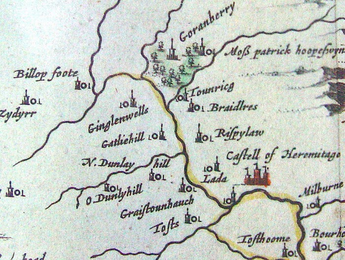
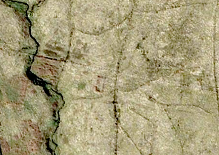
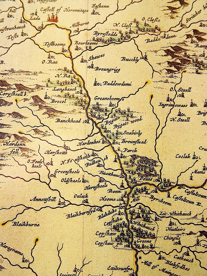
This is the Hermitage Valley from Timothy Pont’s survey of Liddesdale, circa 1583.
For ten years, from 1978 until 1988, my family and I lived at Dinleyhaughfoot, just above the “tower” marked as “Graistounhauch” on the map above, and I know this area well.
But back in those days, there was no “Google Earth,” and almost all of the overflight photographs were held by the Ministry of Defence, and “classified.”
Back in the 16th century, it is reputed that “Liddesdale” could field 3000 riders, and whilst I have commented elsewhere that this figure may have been exaggerated, due to the same riders being counted several times over, depending upon which “warlord” (sic) led the raid…… i.e on some occasions the riders were Armstrong’s (men) and not Armstrongs, (surname) and on the next the same men were Elliot’s (men) and not Elliots,(surname). That still means that Liddesdale, over the centuries was a heavily populated, even an overpopulated valley.
So…… Where are they all…. and where are all of those many thousands of burials?
Where are all of the towers, and other habitations?
Well….. No-one knows…. And the reason, in the main, is that no-one has really bothered to look!
Which is truly tragic. Because the people who were cleared out of this and other valleys, on both sides of the “Border Line” around the time of the Union of the Crowns, were some of the most dynamic people Britain ever produced, and they went onwards and outwards, throughout the world.
Here is a very familiar form of “Irish Hilt” circa 1600, excavated in “Historic Jamestowne”
And here is the basket guard from a Lowland Scots “Disc Hilt” from the same source.
The “Borderers” were hugely responsible for the early colonisation of what is now the United States, and formed a very large contingent in the push west across that Continent.
And yet in their own homeland, because the clearance was so efficient, they are largely forgotten.
The Borderers as an ethnic grouping have almost disappeared, swamped out (in Scotland) to a great extent by the spread of the “Highland Image” of the Scot.
On the English side of the line, perhaps the last remnant is the “Geordie.”
And Tyneside to this day boasts a very large number of the old Border “surnames.” Mostly, because those who didmanage to remain after the clearances of the 16th and early 17th centuries, were forced off the land due to the mechanisation of farming in the 19th and 20th centuries, and they ended up in the mines, steelworks, and shipyards of Tyneside.
But now…… Thanks to modern technology, it is possible to sit at home, and to look for the very locations where the old time reivers actually lived!
This is a satellite shot of “Lada” just to the left of Hermitage Castle on Pont’s map. (or at least I think it is. It has never been excavated.)
The house outline is around thirty feet long, and it lies on a “dry mound” just above a stream.
Look carefully, and you can make out a rectangular field enclosure just below the house.
I was told years ago, that this was one of the locations occupied by “The Croziers.” So if that is you… then you may just be looking at the Ancestral Estates! And there is a fair bet, that some of your forebears are lying there, looking up, from just under that turf….. not too far away at all.
(Bet that makes the hairs on your arms stand up and prickle!)
You know, if this was in the USA……. Native American…… First Nation….. whatever, then all of this valley would be protected, at least until it was properly recorded….. But it’s not…. and so it isn’t!
“Lada” is fairly typical of a Liddesdale “dwelling”….. not a tower at all….. just a small farmstead! And the valley ought to be littered with them. The problem is, that they are hard to see at most times of year, due to an overgrowth of bracken.
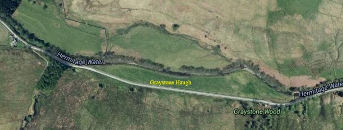
This is “Graystone Haugh”……. and Graystone Haugh Tower ought to be visible just to the left of the yellow text. But it isn’t……
Back in the 1980’s you could still see it, but since then, too many tractors have been over the site, and now it’s gone forever!
And that is the danger. Forestry, Farming, Windfarms. None of which, are particularly friendly to archeology. And without any doubt at all there is a marked reluctance amongst both landowners and councils to record what sites there are.
Go out there, and the last person you are likely to meet is an archeologist!
But here is a little bit more…….
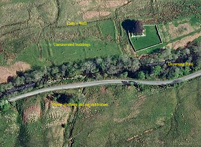
Here is the chapel just to the west of Hermitage Castle. The “Lady’s Well” is more ore less where marked, but so overgrown that I fell into it last time I was down there!
All of that just to the west is pretty much unexplored. The house platform, and rig cultivation is another typical “Liddesdale” dwelling.
The “Drowning Pool” is where the “Cout of Keilder” was allegedly held underwater by the spears of wicked Lord de Soulis’s men.
Another of Hermitage Chapel.
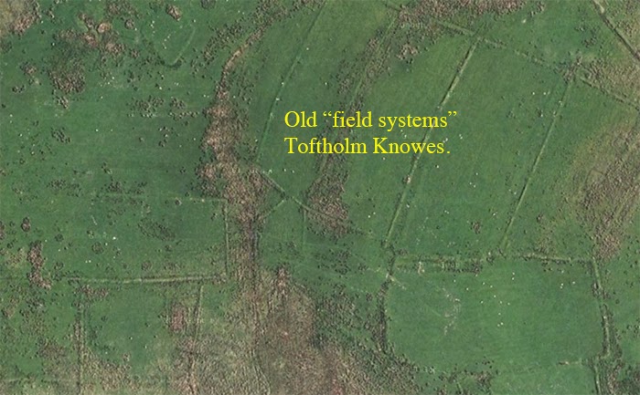
These are ancient turf walled field systems at “Toftholm Knowes” on the hillside south of Hermitage Castle.
And this is a piece of hillside west of Toftholm Knowes.
I’m not sure what all of that is, but it deserves a better look.
“Stells” (the word comes from the Vikings) those stone enclosures, round and square, to herd sheep into are often built out of the remains of stone houses, since no-one liked to carry stone far. The light brown stuff is dried out bracken.
There could be “rig marks” i.e strip cultivation within that open sided rectangular enclosure?
(By now you will have realised that at least some of those old “reivers” were also growing a few “veggies?”)
And this sort of thing just goes on and on.
It’s tragic really, because given time and enthusiasm, it ought to be possible not just to locate all of those old towers and farmsteads, but also it ought to be possible to say just what families lived there. So…. If you are an Armstrong, Elliot, Nixon, Crozier etc., then you ought to be able to go and stand within the outline of the houses that your families once occupied.
But you can’t.
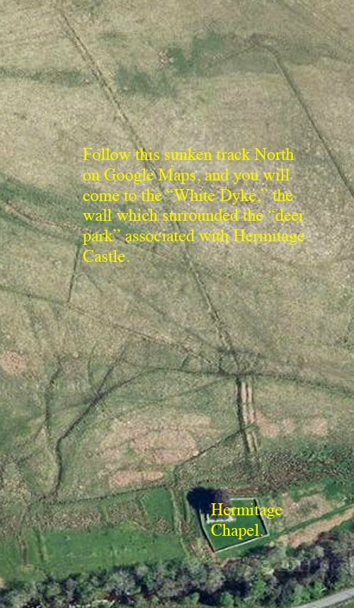
Yet all is not lost, because the Scottish Government, in a strange fit of generosity, has made all of the old maps available, “free gratis” via NLS MAPS! Now combine this with Google Maps, and without moving from your computer you can do your very own research!
Believe me, NLS Maps is one of the best resources ever. But if you want hard copy of the Pont Series on the Border…. Well, we actually do have copies for sale ourselves!
But scroll back to the map at the beginning of this post. See the two towers at the top of the frame? The ones marked “Goranberry.” Well, life is full of little surprises, because although the right hand one is gone without trace……. here are a couple of photo’s of what remains of the other one……..
“Old Gorrenberry.”
And it’s still liveable!
“Bastle House,” Old Gorrenberry, Liddesdale.
A much altered, and considerably modernised “Liddesdale Bastle House.” (Foundations and other “lower bits” probably dating back to the 16th century.
(The “Bastle house” is a sort of “economy version” of the better known and much larger “Pele or Peel Tower….. I’ll try and cover all of that in a later posting.)
Friends of mine used to live here, and farmed the land. You go up them stairs, and back down again into the lower storey.
It’s not recorded by the Historic people up in Edinburgh, but there is little doubt that this is the tower on Pont’s map.
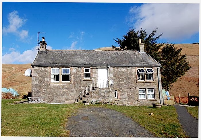
There was a more original one at Toftholm, (on the bottom right of the Pont map.)
That wasn’t recorded either. It was used as a byre, and was demolished around 25 years ago!
Anywhere else in Britain, and it wouldn’t matter so much. But the people of Liddesdale are something of a “lost tribe” (like most of the Border Surnames), and we know almost nothing about them, or their culture. And that above is probably the only remaining inhabitable “bastle house” in the valley.
If you’ve read my earlier post “Hermitage Castle, in the footsteps of the Artists,” then you will also be aware of the “Gorrenberry Kelpie.”
I’ve had many a cup of coffee in that little “bastle” and if you have a feel for such things….. Well all I can say is that it has an “atmosphere”which is second to none. (And a pleasant one at that!)
And that’s a fine stone dwelling for 16th century Liddesdale, and proves that not everyone lived in relatively small turf houses.
That little building is precious, almost unique……..a gem well worth preserving.
11th February, 2014.
Just a small update.
Speculation?
The “bastle” at Old Gorrenberry is just below the “d” in “Old.”
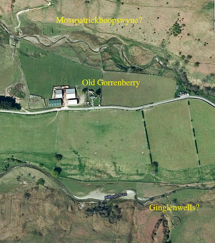
Sooo…… I pulled up the map again, and had a look for Mosspatrickhoopswyne, and Ginglenwells, because, due to the topography of the land, there are not many locations where they could be situated.
The land falls away from “Old Gorrenberry” both to the top and bottom of that frame. It falls to the two burns, and then rises sharply into quite considerable hills.
Remember that I said that they didn’t carry stone far to build those “stells,” and that they sometimes dismantled derelict houses to do so?
Well, pull that frame up on your computer, and have a good close look…..Mosspatrickhoopswyne…. (some mouthful that one is)…. probably lies below, and to the left of the capital “M” above.
And Ginglenwells, is probably below and to the right of the centre of the word itself. There could just be a rig cultivation system visible there, but on the other hand it may just be drainage.
But of course…. you must make your own minds up.
And I have no doubt at all that some archeologist will be spluttering in their coffee over all of this!
Whatever…. It looks like a good afternoon out when the weather gets fine, and I get rid of this flu!
14th of February 2104.
Still stricken down with “lurgi,” but we had to drive down to Newcastleton (Copshawholme to you initiates) yesterday to pick up some paperwork, so we decided to take the scenic route.
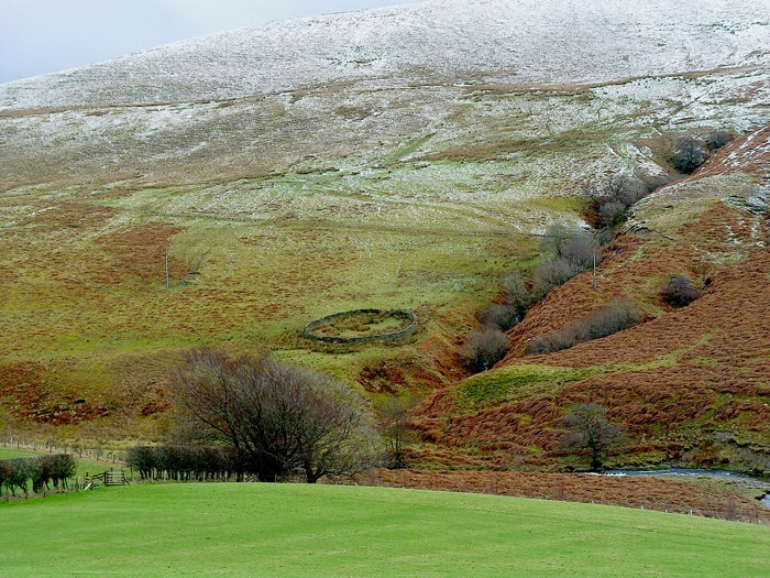
And this is an “on the ground” view of “Ginglenwells.”
It was a difficult drive, over higher ground than this, and we were up above the snow line for quite a way. The family played hell with me for even going out but as they saying goes… “you can’t keep a bad man down!”
Funny how those satellite shots flatten all of the landscape.
And I photographed this, around three hundred yards west……
Now, once again, that has the look of a Liddesdale dwelling….. raised ground…. near stream…. reasonably flat…. stell….. and this one even has a track up to it. So I’ll put that one on the list as well for me “day out.”
And off down the road we went, and a mile or three on, we took the right hand turn and drove down past Toftholme.
(Back to Mr Pont’s Map)
Now…. See Toftholme, top left just below “Castell of Hermitage?” Well drop your eyes down, and you will come to “O.Raa,” and then “N.Raa.”
There is a lot of that about in the Borders. Three sites, but in this case one is missing. It probably ought to read Raa….. Over Raa…… and then Nether Raa.
Meaning Upper, Middle and Lower.
And in this case, one of those names survives to this day.
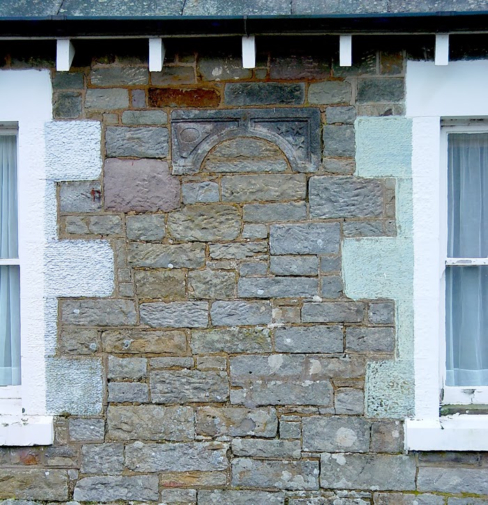
For this, is Netherraw Cottages built probably around 1870.
So……. You ask? Not much to shout about there…..
But…….
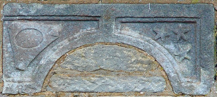
What’s this, built into the stonework between the windows…..?
A “Heraldic Arch” ……. and it’s too small to be a doorhead, or perhaps even a window lintel.
I won’t bore you with the heraldic detail, but the three devices on the right, could be either “stars” or “spur rowels.” But that “thingy” on the left I have never seen anywhere before. It’s not in my dictionary of heraldry, and as far as I can tell, it’s not in any of my “Liddesdale books” either.
Neither does this stone appear to be recorded anywhere at all.
It may have come from one of the towers at “Raa.” But the quality of it suggests the possibility that it may also have come from either Hermitage Castle, or in my own rather humble opinion, from the now ruined Chapel.
Heraldry is a funny thing…. There is a lot of it about in Liddesdale, on tombstones and elsewhere. But unfortunately, there is a problem!
Ye Olde Reivers did use heraldry….. they just forgot to register it!
I mean….. if you were an outlaw…. would you trot off to Edinburgh to register your “Arms.”
Highly unlikely.
But….. You can go up there now, and register a new version. (It’ll cost you mind.) And lot’s of folk do.
And so….. much of the old (and authentic?) heraldry remains “unofficial” to this day.
I’ve been thinking…… and if you are going to try your hand at locating sites in the Borders, then perhaps you ought to be aware of this…..
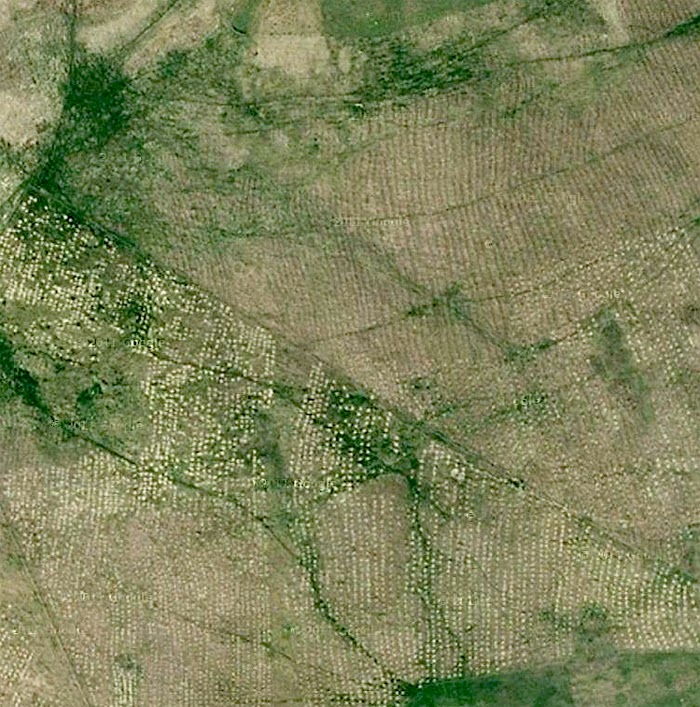
That is the hillside just west of Old Gorrenberry.
And it is the curse of the “Historic” Borders.
Because that is Forestry…. new plantings, and it is gobbling up huge areas of land where the landscape has never been properly surveyed.
It’s not even good wood. It’s most likely sitka spruce….. which grows here like a weed. And few folk even know exactly who owns most of it. A certain well known DJ once had quite a bit. A major tobacco company was involved. Rumours abound of Irish Insurance companies and all manner of others.
I don’t know the mechanics of the finance, but most of it seems to benefit people who never even set foot here.
Frankly it’s poor stuff, grows too quick, and if you’ve ever tried a bit of DIY, then you don’t need me to tell you about it’s structural properties.
And a lot of that wood goes for pulp, some of it even ends up as toilet paper, and currently, there is a saying going the rounds, that everyday, politicians both in Westminster, and Holyrood wipe their backsides on a tiny bit of the Borders!
Ugggh!…. I mean that’s disgusting.
I know that in certain places I will be viewed as anti-development, but that’s not entirely true. We in Britain are very aware of the precious nature of our natural environment, and there exist heavy penalties for those to destroy our wildlife.
All I would like to see, are similar penalties, or stronger, for those, who with no regard for anything but money, deliberately destroy, or refuse to record our historic sites.
But once again, money talks, and perhaps that is too much to hope for.
No… It’s not the Somme…. This is what the landscape looks like after that forestry is cut…..
Here it is in a bit more detail…..
And you can imagine what that does to archeology. But there are other aspects to it as well….
Up here, in the hill country, the soils are thin, poor, and what overlay there is is built up over tens of thousands of years. Some bits are peat, but some locations have very little soil indeed. After they’ve cut like in the photo’s above, they replant…. and what the long term effects on the landscape will be after “they” have finished with it, we have yet to find out.
Also….. the fast run off of water from the heavy drainage installed when the forestry is planted, can cause flash flooding downstream, and there is a general consensus (outwith of the “official view,”) that all of that sitka spruce has raised the acidity of the river waters, with a catastrophic effect on the salmon and trout populations.
Oh, and since I know that you are going to ask…. “Why have they left those few skinny poles still standing.”……. Well, they are for the wildlife that once lived in the forestry to live on! And no…I’m not kidding this time!
You know… all of the red squirrels… birds of prey etc.
We used to have a lovely “squirrel lady” came round once in a while to count and check on the population of “reds,” just to make sure they were being properly nurtured…… Wonder what happened to her?
There’s mile after mile of landscape just like that above, and huge movements of displaced wildlife.
I’d lived up here for very many years before I saw my first badger, but now since all of this harvesting of timber, they have become the commonest form of “road kill.”
16th February 2014.
Shouldn’t have gone out.
Knocked myself back by two or three days!
So, be warned, if you get the flu….. then don’t go out in the snow and the ice. Stay at home in the warm, and nurse a bottle of whisky or something.
But….. Here I am back!
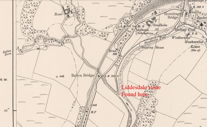
After we left Netherraw, we drove south, and turned for Newcastleton, (better known locally as Copshawholme,) You can see it on the Pont map above, all fenced around.
The actual “Modern” (sic) village wasn’t built until the 1790’s by the Duke of Buccleuch, (well, not personally by him) and what you are looking at is actually a deer enclosure, liberally sprinkled with dwellings, the names of which will be familiar to many aficionado’s of the reivers. (particularly the “Armstrongs”.)
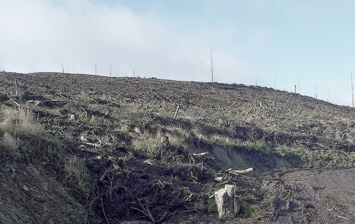
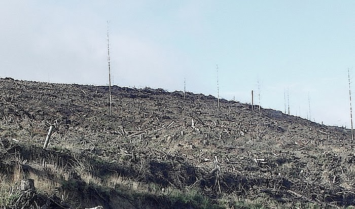
But, I digress…….. See where the two rivers join (part?) on the map? Well, just below that point is where the “Liddesdale Stone” was found.
Never heard of it?
Well that’s it below.
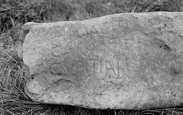
The Liddesdale Stone.
Detail of inscription.
And this is what it says.
“Here lies Carantus, son of Cupitianus.”
Now those are very poor photo’s, taken way back in 1933, when the stone was found. How very odd that no-one has bothered to update them. Because…… this (depending upon who you ask) is the earliest Christian tombstone from Scotland!
In fact that statement is not exactly true, because the stone has been dated to the late 5th or early 6th centuries. And back then there really were no Scots…….. Which is probably why it is so little known.
Carantus, and his Dad, Cupitianus, were native Britons. What the Anglo-Saxons would refer to as the “Wealas.” Who are known today as “The Welsh.”
See my earlier posting, “Arthur in the Borders.”…… Because that is the thing….. here we have a memorial stone to two men, who are Native British Christians. Living within the “Arthurian Era.” Just ten miles from “Arthur’s Seat,” and around twenty two miles from Arthuret.
Conclusion….. If there ever was an “Arthur” on the Borders, then there is a good chance that he knew either Carantus, Cupitianus, or both of them.
So why is this not well known…… And once again I don’t know.
That stone above was an accidental find by a wee laddie….. Just what would turn up if there was ever an organised and systematic search?
Here is the best account I can find of the discovery……
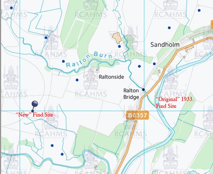
“In August 1933, a stone was found in the river bed of the Liddel, just below the inflow of Ralton Burn.
It was noticed by a small boy walking with his father, and described by the boy as having “printing on it.” It had evidently been incorporated in a dyke which had been washed away by recent flooding.
It was recovered form the river, and found to measure 5′ 8 inches. by 1′ 9 inches. by 11 inches., and to carry the inscription “Hic Iacet Caratini fili Capiteiani” (sic) which translates as “Here lies Carantus,
son of Capitanus (or Capitaneus)
The stone was dated at the time, or very shortly afterwards as late 5th or early 6th century, by Sir George MacDonald, K.C.B.
The Stone was presented to Buccleuch Estates, who in turn presented it to the National Museum.”
Who quite frankly have never made enough of it.
So…… There is no doubt at all where stone was found.
In the bed of the river Liddel, where the Ralton Burn runs in.
But where did it originally stand? In all probability not too far away. Possibly a little upstream?
Maybe….maybe not.
Unfortunately, a road alignment a few years back somewhat devastated the land just upstream, and as far as I know, no investigation of that land was made at that time. (I could of course be wrong).
But here are a couple of interesting photo’s.
Now this, without a shadow of a doubt, is where the “Liddesdale Stone” was actually found, just to the left of the “F” in “Found.”
And that, shows the “modern” location on the Government’s Canmore website!
Both the location, and the map reference have been changed. The description however, remains the same.
I can’t account for that. But I’ll ask around, and update as necessary.
Do you know, the more I think about it…… A lot of the pieces of the “Arthurian” story exist…… It’s just that no-one really wants to put them into place.
There was no “Arthur” because there are no “Arthurian artifacts,” and there are no “Arthurian artifacts” because there was no “Arthur.”
Reputations are at stake, and so, no serious academic likes to even mention “The Arthurian Era.”
Funny isn’t it…… I mean it’s all a bit like the 9th Legion. (See my earlier posting on that!)
But down there, where the Ralton Burn, joins the Liddel, wouldn’t it be nice to see a little bronze plaque, and perhaps Tourist Marker.
Because this is a Christian country….. and “The Liddesdale Stone” is quite likely one of our earliest Christian tombstones.
And it is of immense importance.
And finally, and on a somewhat lighter note…..
Whilst I was searching around for interesting info. I decided to have a look at a circular grove of Alder trees just alongside the A7 north of Langholm.
Funny things these circular groves.
They are supposed to be incredibly old…. grow out over from the remains of one original tree, and the process just keeps on going.
But Alders are weird anyway. Scandinavian legend associates them with the Alder Maidens. Elf like creatures who dance at night, and lure young men away never to be seen again!
From the front they are beautiful, but their backs are hollow!
So beware!
Nils Blommer 1850. Alder Tree Girls.
These are they dancing!………. In a circle!
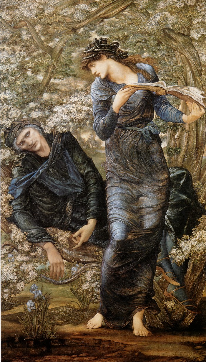
I think that with the Alder maidens we are touching on a very ancient tradition indeed. Remember Nimue imprisoned Merlin within a tree.
This is Sir Edward Coley Burne-Jones. ” The Beguiling of Merlin” 1872-77.
It illustrates Nimue reading from a book of spells, in order to lock poor old Merlin within, this time, a hawthorn tree.
In Shakespeare’s “The Tempest.” Ariel is imprisoned within a pine tree by the witch Sycorax.
Can’t find a decent illustration of that one. There are one or two about, but they’ve turned Ariel into one of those little “fairys” with butterfly wings!
However….. The subject of trees, sinister maidens, and the locking of persons within trees, is worth more research.
But look again at that photo of the Alder Grove. Because once again there are some interesting and unrecorded enclosures. And that photo was taken in May, you can tell by the hawthorn blossom, and in the morning. (angle of the shadows)
The time of year and light angle are important, because in differing light angles, different features of the landscape become visible. And Google maps get updated every few years. So if you see it today, you may well not be able to see it next year.
But give it a go….. because it is well worth it.
Oh, by the way…… You arms and armour enthusiasts may be interested to know that folklore and arms and armour do have a connection.
Much of what we know is due to good old Gustavus Adolphus of Sweden!
…… Who was more than just a soldier, he was also a folklorist, and instructed his priests to record all of the records of the old beliefs. Something which was certainly not done in Scotland!
Agnes Randolph of Dunbar, sometimes referred to as “Black Agnes” or the 4th Countess of Moray lived from 1312 to 1369. She is remembered primarily for her successful defence of Dunbar Castle against an English siege that lasted five months in 1338. The wider picture in Scotland at the time is set out in our Historical Timeline. Agnes was the daughter of Thomas Randolph, 1st Earl of Moray, a nephew of Robert the Bruce. She went on to marry Patrick Dunbar, 9th Earl of Dunbar and 2nd Earl of March (the March refers to an area of Northumberland known at the time as the East March). Perhaps because of his landholdings both sides of the border, Patrick Dunbar had, before his marriage to Agnes, tried to steer a middle course during the Wars of Independence, even sheltering Edward II of England at Dunbar Castle and helping him escape after the Battle of Bannockburn in 1314. Dunbar Castle had been refortified in 1333 and occupied by English troops, but by the end of 1337 was back in the hands of Patrick Dunbar: or rather in those of Agnes Randolph of Dunbar, as Patrick was away on military duties. On 13 January 1388 an English army under William Montague, 1st Earl of Salisbury, arrived in Dunbar and demanded the surrender of the castle. Despite the fact that she was accompanied only by servants and a few guards, the 26 year old Agnes is reported to have replied: “Of Scotland’s King I had my house, He pays me meat and fee, and I will keep my guide auld house, while my house will keep me.” The English army in Dunbar was the last throw of the dice by Edward III of England in his increasingly unsuccessful (and increasingly unenthusiastic) efforts to replace David II on the throne of Scotland with Balliol. Montague was one of the best generals of the day and was expected to take Dunbar Castle with little delay. He had at his disposal mangonels, catapults capable of hurling large boulders, which had been brought in by sea, and he set to work slowly demolishing the castle’s defenses. Agnes’ response was to go out onto the ramparts at the end of each day with her ladies-in-waiting and, in full view of the English, dust down the damaged stonework with their white handkerchiefs. When the English tried to attack the main gate of the castle with a battering ram known as a “sow” the defenders destroyed it by dropping the boulders first used in the attackers’ mangonels onto the sow from the ramparts. Meanwhile, the castle was resupplied when local fishing boats delivered supplies to the castle’s sea gate despite the efforts of Genoese galleys hired by the English to cut the defenders off from just this sort of support. Perhaps the critical moment of the siege came after the English captured Agnes’ brother, John Randolph, 3rd Earl of Moray. They brought him to Dunbar and threatened to hang him if the defenders did not surrender. Agnes invited them to proceed, on the basis that this would allow her to inherit the Earldom of Moray. Their bluff called, the English spared John Randolph (only for him to die in the Battle of Neville Cross in 1346). By the beginning of June, Edward III was becoming increasingly unhappy about the cost of maintaining the siege at Dunbar Castle, and on 16 June 1338, after a siege of just over five months, the English withdrew, leaving the defenders under Agnes Randolph of Dunbar victorious. Accounts differ about whether Agnes and Patrick had and were survived by any children, and it seems their titles and inheritances passed to the children of the marriage between Patrick’s younger brother and Agnes’ younger sister. Though there is a story (which doesn’t square with the way the Earldom of Moray actually passed to the next generation) that suggests that they did have a daughter, also called Agnes, who was said to have become a mistress of David II, and was his intended wife when he died in 1371.
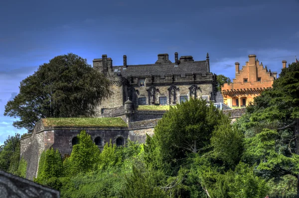
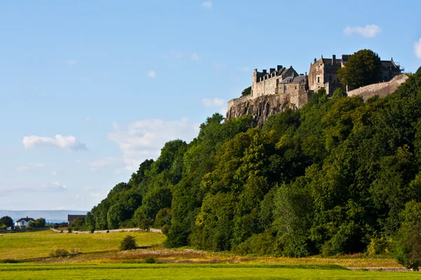
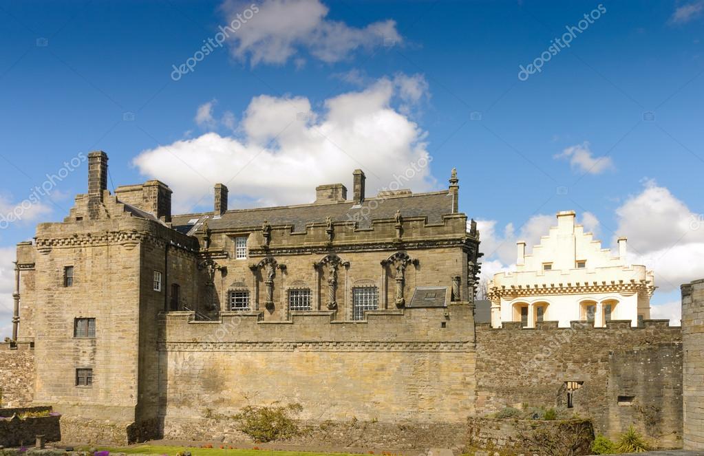
Stirling Castle is one of the largest and most important castles, both historically and architecturally, in Scotland. Several Scottish Kings and Queens have been crowned at Stirling Castle, including Mary, Queen of Scots, in 1543. There have been at least eight sieges of Stirling Castle, including several during the Wars of Scottish Independence, with the last being in 1746, when Bonnie Prince Charlie unsuccessfully tried to take the castle.
All the above photos can be purchased at the following link.
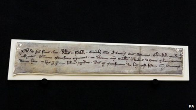
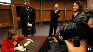
The 700-year-old letter is from King Philip of France and mentions Wallace
A 700-year-old letter thought to have been in the possession of William Wallace has returned to Scotland.
The fragile document was held in England after it came to light in the Tower of London in the 1830s.
It is now on long-term loan to the National Records of Scotland following an agreement with the National Archives in Kew.
The letter will go on display to the public this summer at the Scottish Parliament in Edinburgh.
The letter, which was from King Philip of France to his officials at the Vatican, mentions Wallace by name.
It will be exhibited alongside the famous Lubeck letter, sent by Wallace shortly after the Battle of Stirling Bridge in 1297.
‘Fascinating fragment’
Culture Secretary Fiona Hyslop said: “I am delighted to welcome the Wallace letter back to Scotland.
“It is one of the few surviving artefacts with a direct link to William Wallace and a fascinating fragment of our nation’s history.
“To have it here in Scotland, where it can be viewed by the Scottish public, is very significant indeed.”
The letter from the French king asks his agents in Rome to help Wallace in business with Pope Boniface VIII.
It also strongly suggests Wallace intended to travel to Rome, although it is not known if he reached his destination.
The paperwork has puzzled historians and aroused speculation about its origins and precise link to Wallace.
Last year, an international team of medieval experts concluded the letter was French, was issued on 7 November, 1300, and was likely to have been in Wallace’s possession.
George MacKenzie, head of National Records of Scotland, said: “This document is an enigma.
“It’s a letter from the French king to his officials at the Vatican mentioning Wallace, but we don’t know what his business was with the Pope.
“What we do know is that the document still fascinates, 700 years after it was written.”
Its return to Scotland follows a campaign by the Society of William Wallace.
National Records of Scotland has agreed to borrow the letter from 2012 to 2014, and it will go on display in both years.
Officials are discussing means of allowing the document to be housed in Scotland in the longer term.
The fragile document can only go on display under controlled lighting for a limited period every few years.
Duncan Fenton, of the Society of William Wallace, said: “We have been campaigning for years for this letter to be returned to Scotland and this is a fantastic result – not just for us, but for the Scottish people who will be able to see this document with their own eyes and feel a connection to William Wallace.
“We do not have a lot of tangible links with Wallace as most of the documentation has been destroyed, so to have something that Wallace actually touched is a massive boost for Scotland.”
Back in 2009 BBC reports
The fragile document was held in England after it came to light in the Tower of London in the 1830s
MSP demands Wallace letter to be returned.
A letter carried by William Wallace when he was captured by English forces in 1305 should be returned to Scotland, a Nationalist MSP has claimed.
The document, known as the Safe Conduct, was written by the King of France and was supposed to guarantee Wallace safe passage to visit the Pope.
It is currently held at the National Archives in Surrey.
South of Scotland MSP Christine Grahame said it should be in the National Museum of Scotland in Edinburgh.
The Safe Conduct was in Wallace’s possession when he was captured in Robroyston in 1305 – eight years after he had led a Scottish army to victory against English forces at the Battle of Stirling Bridge.
It was written by King Philip IV of France and has been held in England since Wallace was hanged, drawn and quartered on 23 August 1305 after being found guilty of treason. It is currently kept at the National Archives in Surrey.
Ms Grahame has lodged a parliamentary motion calling for the return of the letter, and also lodged a parliamentary question asking if Scottish ministers will make a formal request to have it returned.
“This is a very significant historical document related to Scotland’s most iconic and lasting national hero,” she said.
“In the year of homecoming it would be fitting to see this document finally returned to Scotland.
“There are very few artefacts around today that we know for certain Wallace handled and held in his possession.”
Ms Grahame said it would be “entirely inappropriate that it should languish, forgotten in some closed drawer in Surrey and urge the UK National Archive to pass it to the National Museum of Scotland where it can be properly displayed.”
She claimed the document will be “an inspirational boost” for Scots to return for the Homecoming celebrations.
Tory deputy leader Murdo Fraser last year called for the only surviving document issued by Wallace to be returned to Scotland.
The Lubeck Letter was sent by Wallace and Andrew Murray in 1297 to notify the merchants of the German city of Hamburg that Scottish ports were open again for trade. The letter is held in Lubeck.
The Lubeck Letter was sent by Wallace and Andrew Murray in 1297 to the mayors of Lubeck and Hamburg.
It was written following victory at the Battle of Stirling Bridge and informed German merchants that Scots ports were no longer under English control.
A parliamentary motion asking that it be released from Lubeck’s National Archives has been lodged.
The motion was lodged by Mid Scotland and Fife MSP Murdo Fraser who believes it is one of the most significant documents in the country’s history.
The Conservative politician said: “The letter is a link to a pivotal point in Scotland’s history and gives an insight into William Wallace as the statesman and politician.
“William Wallace is rightly remembered as a hero to Scots for his great victories on the battlefield but this letter reveals another side to him which is not always mentioned in the history books.”
The letter has previously been lent to the Scottish Parliament for an exhibition and Mr Fraser wants ministers to begin a dialogue with the City of Lubeck’s National Archives about having it on “permanent loan”.
Mr Fraser said: “I understand that Scotland has no claim for ownership of the item but I hope that goodwill and co-operation could result in the letter returning to Scotland.
“I would welcome the day when Scots are able to see the Lubeck Letter and the emblem of William Wallace in their country and this would be a gift for which Scotland would be forever indebted to the City of Lubeck.”
If the document, which is thought to carry the only known impression of Wallace’s own seal, is returned to Scotland, Mr Fraser would like to see it stored in the Wallace Monument, near Stirling.
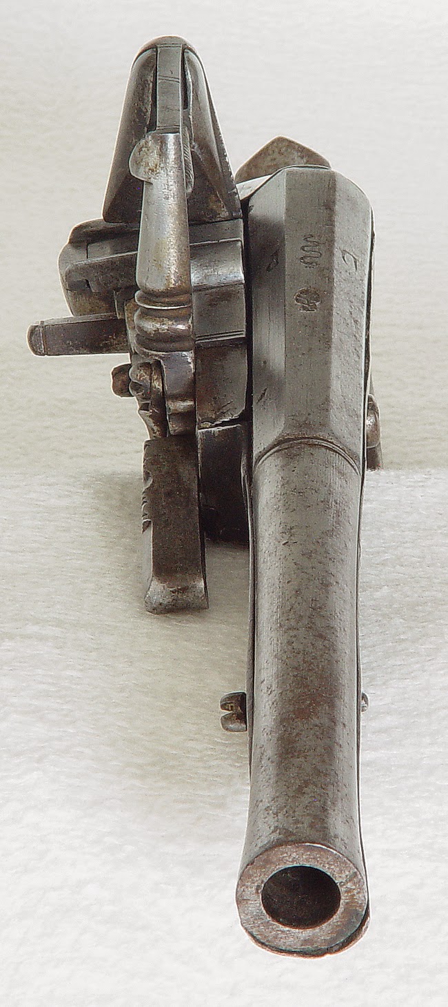
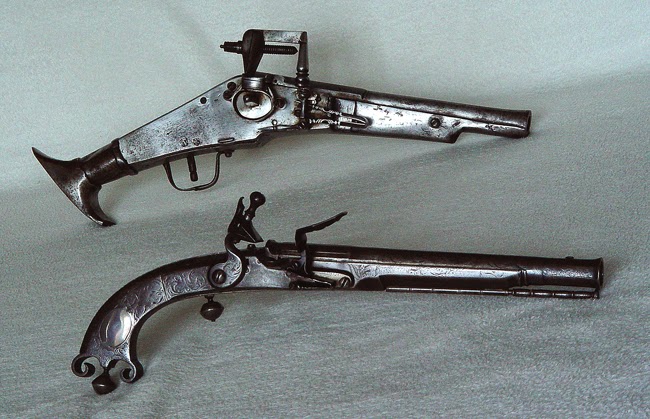
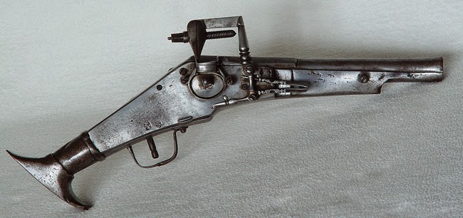

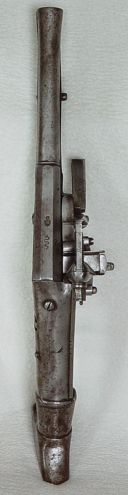

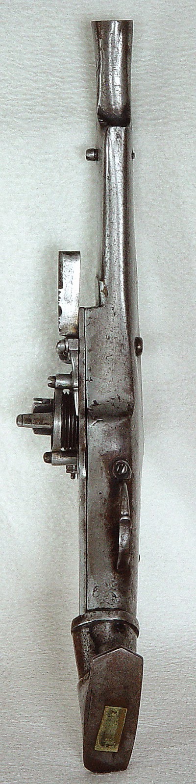
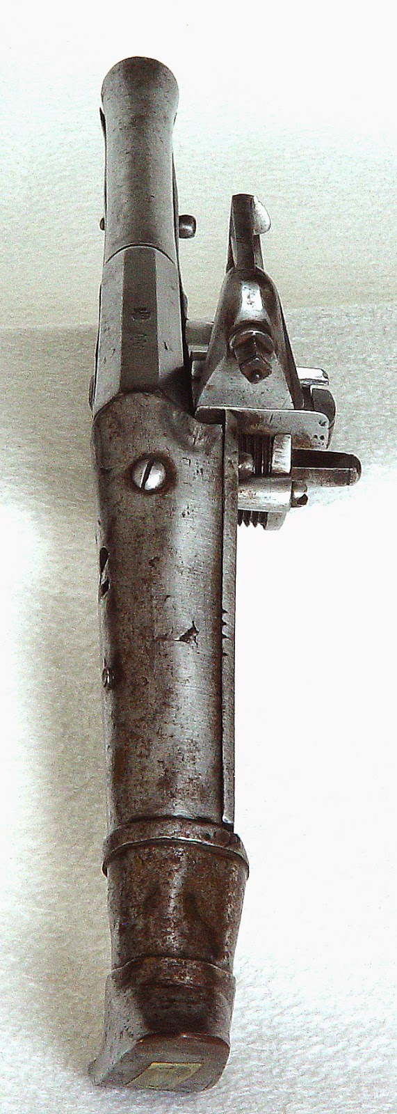
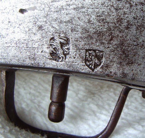
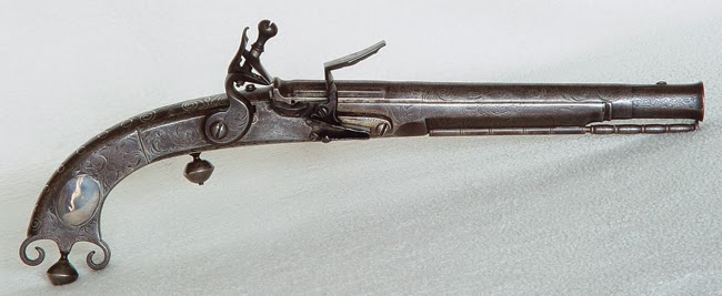
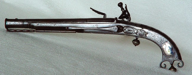

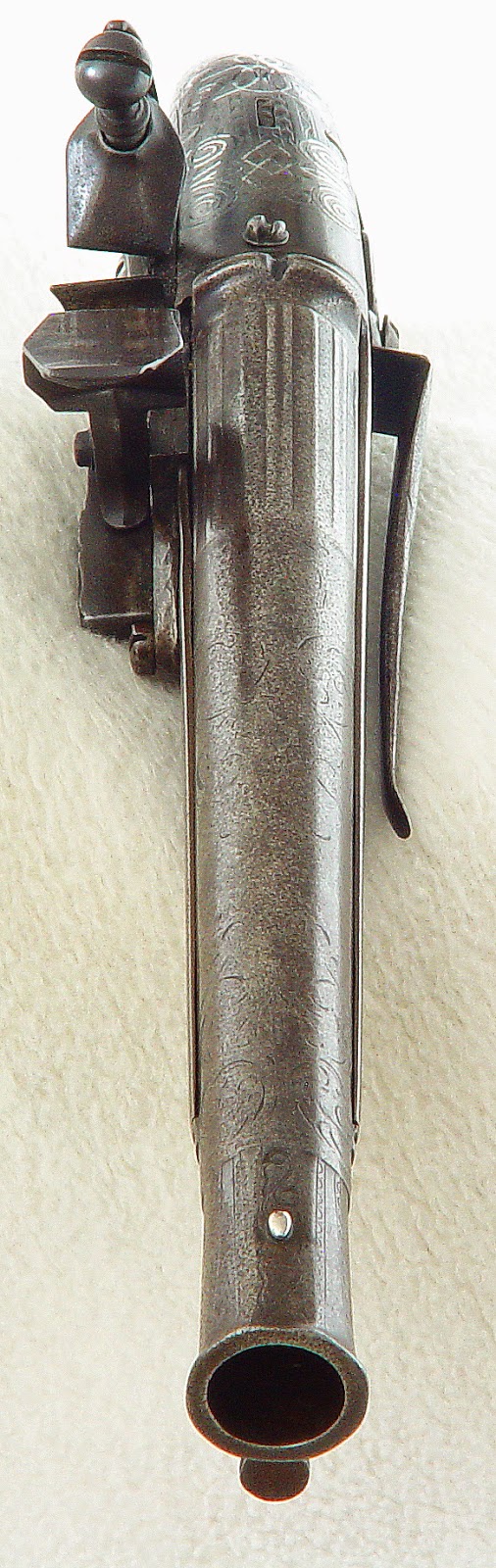
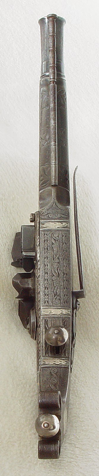

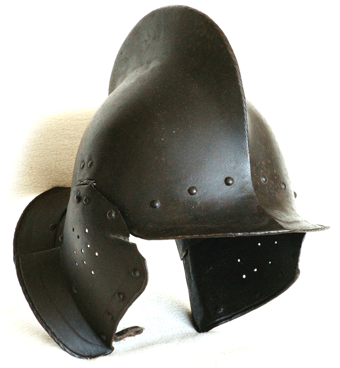


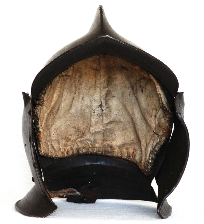
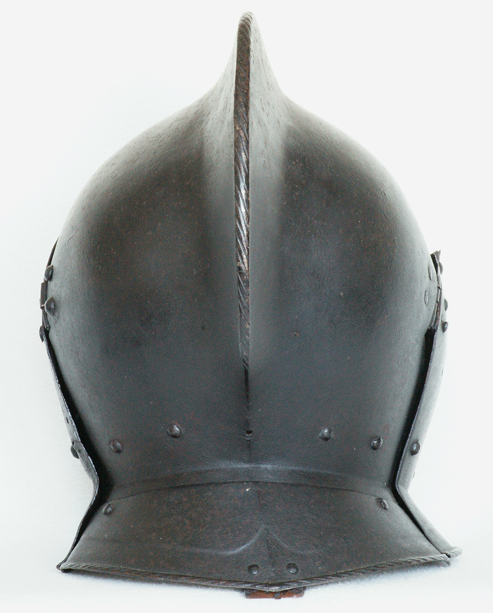
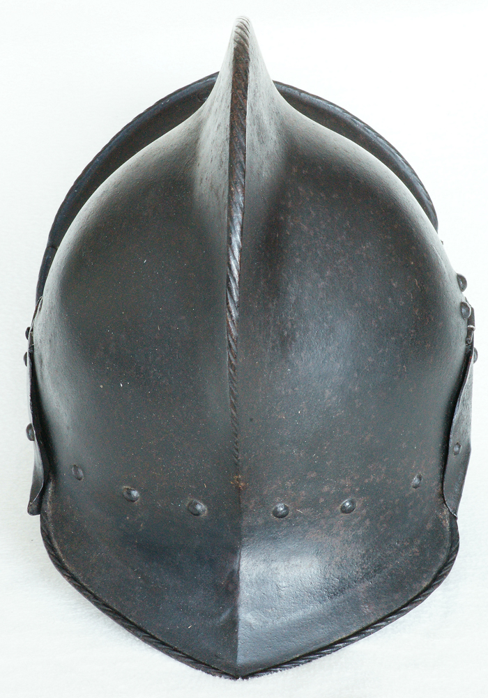
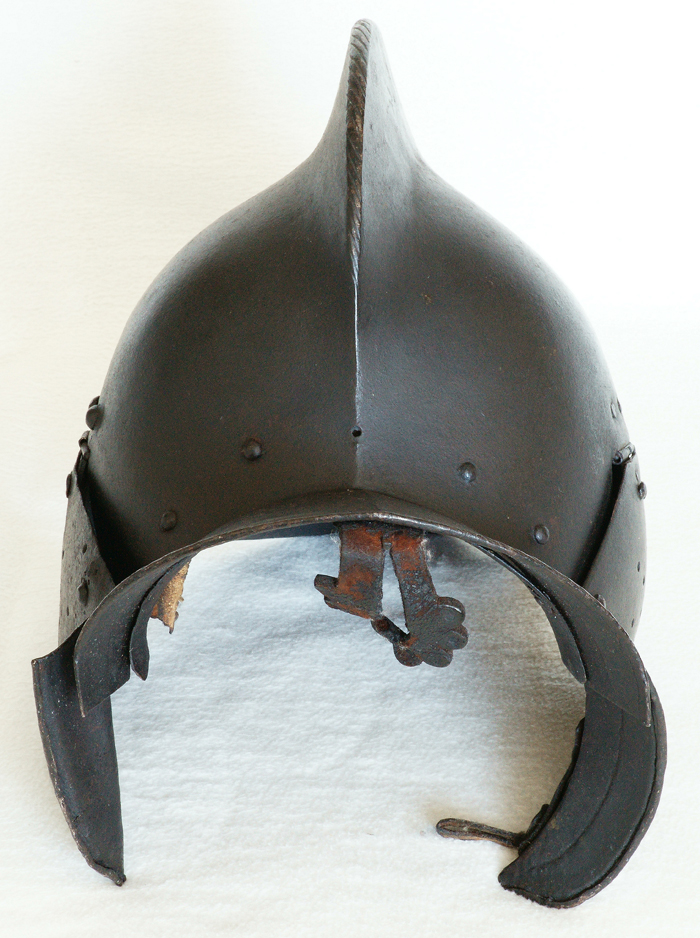

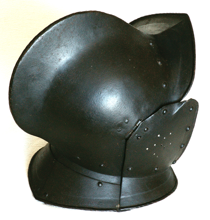
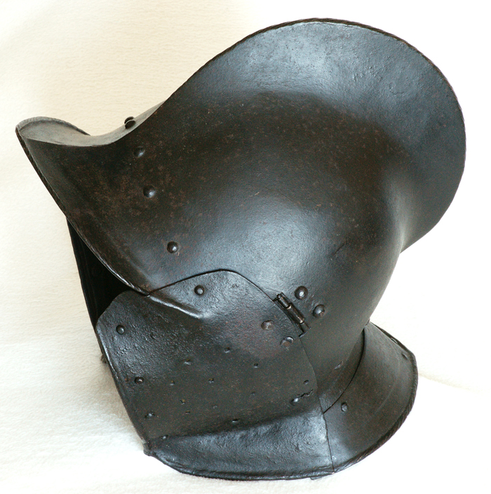
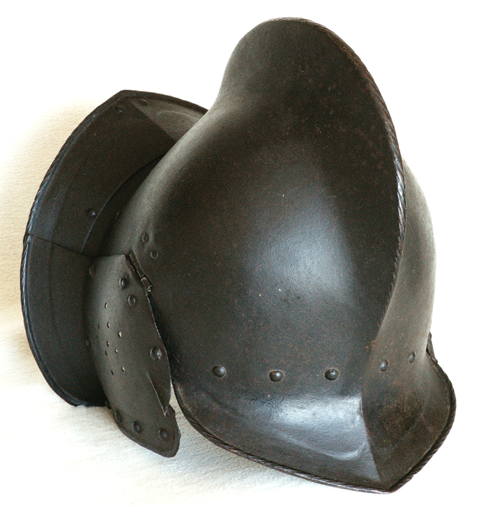
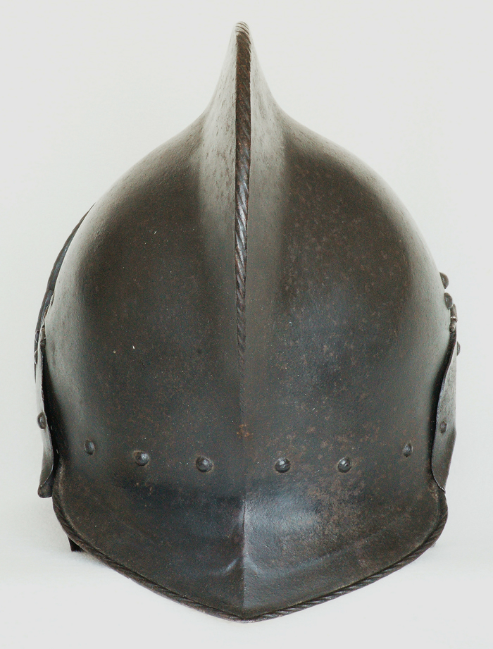
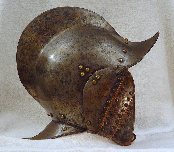

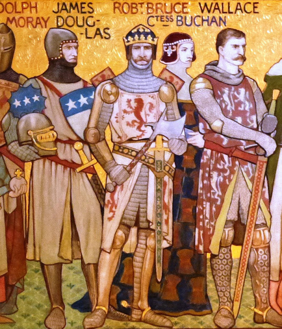
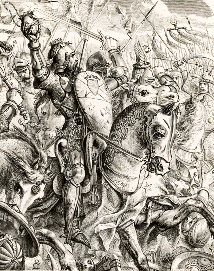

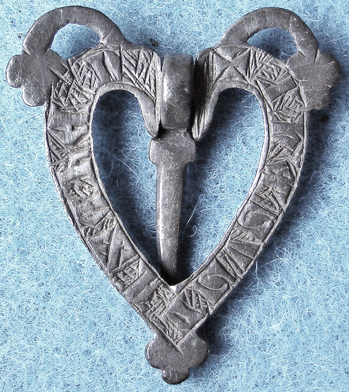

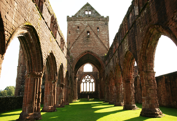
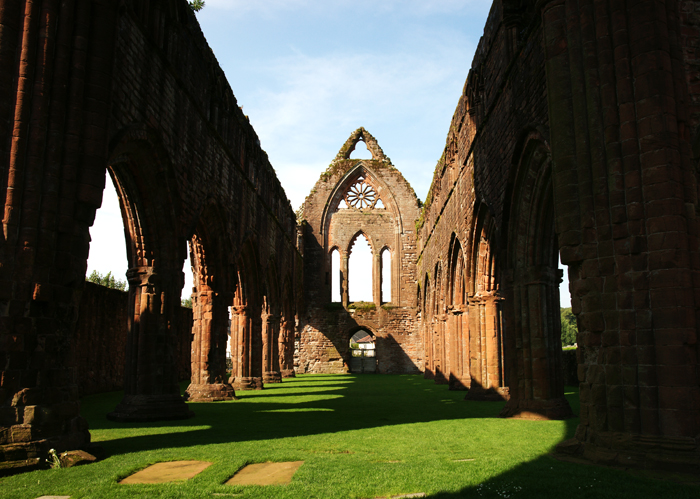
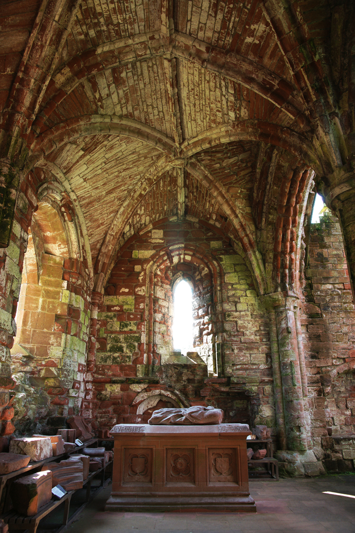
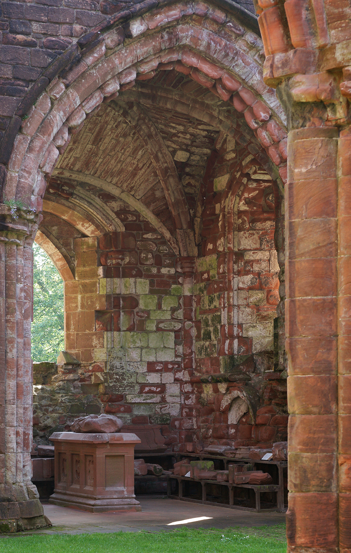
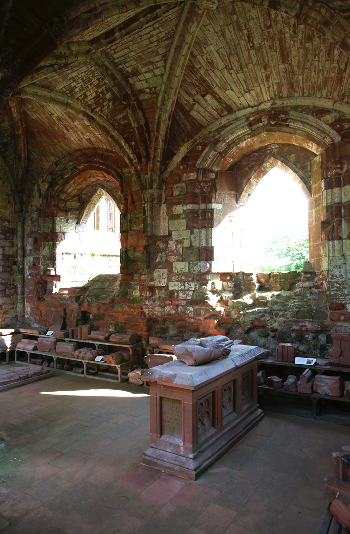
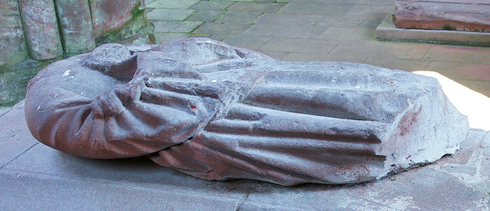
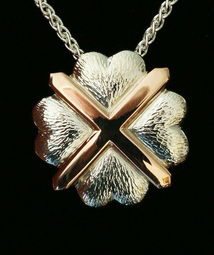
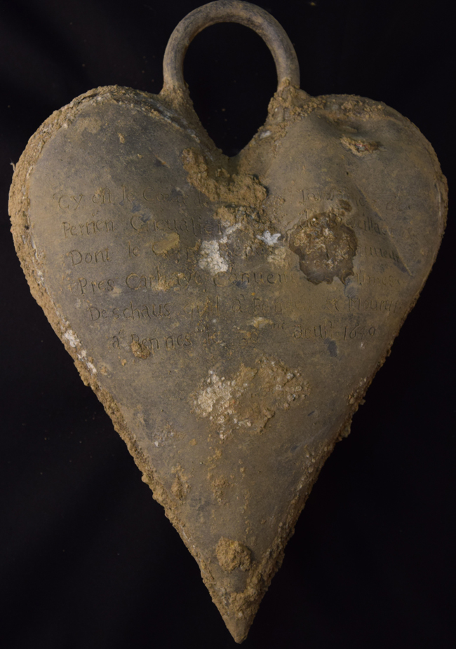
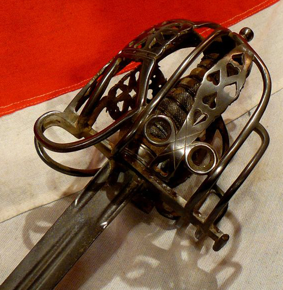


 From inside the caphouse with new roof and walls.